Living here in the Bay Area, we are blessed with a variety of hilly rides though the forest and more. But there are four key peaks to ride up that I'm calling the "Big Four Bay Area Summits":
- Mt. Hamilton at 4,265 ft

- Mt. Diablo at 3,849 ft
- Mt. Umhunhum at 3,489 ft
- Mt. Tamalpais at 2,579 ft

All of these can be ridden from near sea level to the summit so the elevations at the summit are aligned with the total climb, but not the same. This makes them a 'clean' achievement to ride to the top.
Note: Some include Mt Saint Helena in the far North Bay but I'm going with the ones you can see from the main Bay as prominent, independent peaks.
It's also worth acknowledging that there are far more official peaks in the Bay Area. Many of them are taller than Mt Tamalpais (Black Mountain for example at 3,747 ft), but arguably none have the same prominence. (See a full list here) or aren't rideable.
So, why am I writing about this now? Because I set out to climb all four this Winter before the heat makes some of them more difficult. Let's take a look at each, starting with the shortest. Then you can do them yourself.
 Mt Tamalpias

While the lowest of the four, Mt Tam is a dramatic and beautiful peak to ascend. It can be seen clearly from San Francisco and on the approach. Climbing it takes you through beautiful forests including the 'back door' to Muir Woods. Along the way you get view of the Pacific and San Francisco.
This particular route is planned to start in San Francisco so that you get to ride the Golden Gate Bridge (better to ride than pay the car toll), through Sausalito and Mill Valley before beginning the ascent and then returning to Chrissy Field. It is a scenic and thus tourist-filled route in San Francisco. Parking is available at Chrissy Field if it's not too busy. If you're coming via transit, it's an easy ride along the Embarcadero through Fort Mason from either BART or Caltrain.
- Route: https://ridewithgps.com/routes/50036359 42 miles, 3700 feet of climbing
- Pictures: https://gallery.rochte.photo/Activities/Mt-Tamalpais-road-ascent-from-SF
- Video: https://youtu.be/FAIjYehqBTY
 Mt Umhunhum

Despite being the 3rd highest peak, I think this is the hardest climb. The main climb averages ~10% with peaks of nearly 17%. I was begging for 'one more gear' much of the way up.
This is a route planned to allow access via Caltrain from areas outside of San Jose. For driving and shortening the route, you can park down near the bottom of Hicks Rd. It is designed to start at the less-served Tamien station so you can plan to catch the right train. Then return whenever to Diridon where there is a train every 30 minutes or less.
The initial ride is relatively flat along the Highway 87 bikeway (meh) and parts of the Guadalupe Creek trail (nice).
The real climb starts at Hicks Road and keeps going all the way to the top. On return, it diverts over to Los Gatos to pick up the lovely Los Gatos Creek trail at Vasona Park.
- Route: https://ridewithgps.com/routes/49798968 43.5 miles, 4200 feet of climbing
- Pictures: https://gallery.rochte.photo/Activities/Up-Mt-Umhunhum-from-San-Jose
- Ride Video: https://youtu.be/wapQMRbbwno and for real nerds, the whole descent: https://youtu.be/V_ykaWDaQ-Q
 Mt Diablo

Now, when you're ready to add 500 more feet to the peak, head over to Mt Diablo. It is clearly visible from nearly anywhere along the Bay. It's the big, dormant volcano east of San Francisco.
This route starts at the Walnut Creek BART station for easy access to the North Gate of the park. You could also park anywhere in Walnut Creek to start.
The out/upbound route has a short bit on high-traffic roads in Walnut Creek. But it then runs along canal trails until you are in the countryside. The main road through the park and up the mountain is posted 25 mph most of the way and has many bike turnouts (that you must use). This leads to mostly well-behaved traffic that can wait until the next passing opportunity as it comes soon. On a winter Friday, I saw as many bikes as cars. Weekends in the summer will be quite different but I'm told it is still pretty good with the turnouts.
The only real section with more than 10% grade is the last 100m to the top. The rest is single-digit grades. Long but not steep. The 'real' climb averages ~6% and a true single-up, single-down climb.
The descent is LONG and relatively fast. But there aren't really any scary steep or sharp sections. It's ok for any rider who is comfortable on a descent.
Once back in town, the return route deviates a bit and stays on the main road with cars but a wide bike lane until you catch a different canal trail that drops you off near the BART station.
- Route: https://ridewithgps.com/routes/49882230
- Pictures: https://gallery.rochte.photo/Activities/Mt-Diablo-20250307
- Video: https://youtu.be/uy4ZkIXo2Vw
 Mt Hamilton

Finally, the big one, Mount Hamilton. At the top is the oldest mountaintop observatory built in 1887 with what was then the world's largest telescope (and still one of the biggest refracting ones). Read more: https://en.wikipedia.org/wiki/Lick_Observatory If you go on a weekend, you can get a tour. If you miss the timing, at least look around. More info
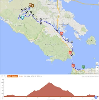
Again, this route is transit-based and starts at Caltrain Tamien station to allow different routes each way across San Jose and be a tiny bit shorter for going up Quimby. It's worth noting that using Quimby Road to access Mt Hamilton is the steeper option. But it is lovely and seems somewhat less traveled. You could go up Alum Rock and then Mt Hamilton Road the whole way. You can also drive and park at Quimby or Alum Rock.
While the summit is 'only' 4,200 feet, the ride climbs 5,500 feet over 50 miles. This is because you have to get in and out of the valley where Grant Park is located in both directions along with an additional smaller valley. But on a clear day, the reward is the amazing view at the top
- Route: https://ridewithgps.com/routes/49969851
- Pictures: https://gallery.rochte.photo/Activities/Mt-Hamilton-March-19-2025
- Video: https://youtu.be/jvAHW9RXs5U
Comments
Post a Comment